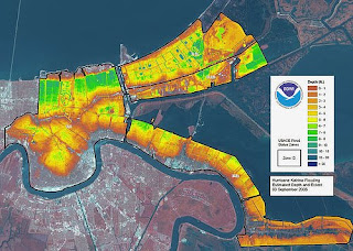
Lidar (light detection and ranging) is a form of airborne remote sensing which, according to our class notes, "uses a laser (light amplification by stimulated emission of radiation) instead of radio or microwave radiation."
This lidar map of New Orleans helped rescue crews and other emergency officals get a sense of the destruction left in the aftermath of Hurricane Katrina.
web site - http://flickr.com/photos/81876992@N00/43339456/
No comments:
Post a Comment